Trastevere Follow-up
December 21, 2016
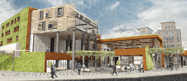
project rendering by Tyler Kirkpatrick
Following up on the previous post, now that the semester has come to a close, I’d like to share some observations about how students from California approached designing for a complex and difficult site in central Rome. Some common themes emerged.
- The first challenge they found on the existing site was the inconsistent design of public space, relentlessly occupied by cars, poorly maintained, unclearly defined. I encouraged them to think specifically about the ground plane, how to keep it accessible, to define it with paving, landscaping, and street furniture to make it clear who had priority where. We removed cars from the surface but put structured parking below their new building(s) for motor vehicles that need for valid reasons to be stored locally. The result in almost all cases is an urban space for people. Where today pedestrians are humiliated when attempting to cross to Ponte Palatino, most projects proposed workable solutions, either significant traffic calming or separation of motor vehicles from people.
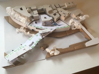
project model by Marcus Simons
- Access to the river is now difficult, students observed, separated as it is by the speeding Lungotevere and the twelve meter drop, connected only by poorly maintained stairs. Only a few students were able to resolve this in their urban interventions with new ramps or stairs. However, for several students Ponte Palatino, currently the most panoramic viewing place for the river, but also the most sacrificed by cars, became a new public place. One student even reconnected the ancient Via Aurelia to the Foro Boario at the ancient level, passing below the traffic on a new bridge.
- The East Trastevere site, students observed, works at two scales: that of the infrastructural face toward and across the river which seemed to demand a large gesture, and that of the neighborhood behind, more intimate and variegated. Some projects made bold gestures to the greater context, ambitious but out-of-scale with the neighborhood. Others tried to fit the existing geometry.
- The existing ministry building acts as an obstacle around which pedestrians have to move; most of the interventions, even those that kept parts of the building, opened up the site to allow more porosity. The resulting urban pathways, in the best cases, provide the kind of complex options for movement we recall from Nolli’s plan, before so many streets were plugged or widened.
- All the students were conscious of siting their buildings to benefit from natural lighting, passive solar heating and ventilation. They strove to create public spaces that would be pleasant in a range of seasons. At least a few students made efforts to address the material reuse of demolished buildings and the future lives of their own.
Here are a few images of some of the projects.

Suki Kwan

Ana Godoy

Dylan Snelling

Juliet Luty

Marcus Simons

Rachel Recksiedler

Isabeau Guglielmo

Griffin Chierici

Annelise Barbieri

Chris McCoy

Mengdi Zhang

Nicholas Low

Allen Leu

Tyler Kirkpatrick

Nicolas Rademacher

Ben Clark
No comments yet
